- Автоматизация
- Антропология
- Археология
- Архитектура
- Биология
- Ботаника
- Бухгалтерия
- Военная наука
- Генетика
- География
- Геология
- Демография
- Деревообработка
- Журналистика
- Зоология
- Изобретательство
- Информатика
- Искусство
- История
- Кинематография
- Компьютеризация
- Косметика
- Кулинария
- Культура
- Лексикология
- Лингвистика
- Литература
- Логика
- Маркетинг
- Математика
- Материаловедение
- Медицина
- Менеджмент
- Металлургия
- Метрология
- Механика
- Музыка
- Науковедение
- Образование
- Охрана Труда
- Педагогика
- Полиграфия
- Политология
- Право
- Предпринимательство
- Приборостроение
- Программирование
- Производство
- Промышленность
- Психология
- Радиосвязь
- Религия
- Риторика
- Социология
- Спорт
- Стандартизация
- Статистика
- Строительство
- Технологии
- Торговля
- Транспорт
- Фармакология
- Физика
- Физиология
- Философия
- Финансы
- Химия
- Хозяйство
- Черчение
- Экология
- Экономика
- Электроника
- Электротехника
- Энергетика
Results. Conclusions
4. Results
The marginal zone is a characteristic feature of the Svalbard outlet glaciers. There are discontinuities of the glacier cover, the formations of deep faults oriented mostly across the direction of the glacier movement along the valley, (i.e. parallel to its front) are observed in such areas. Deep cracks should determine a different nature of the reflect solar radiation from the glacier surface, which should affect the albedo values of such surface areas, from our point of view. For example, we recorded a decrease in the surface albedo in the zone of deep cracks formed by the snow-ice cover failures over subsurface water streams in the area of the antarctic “Progress” station by the UAV [5]. We expected to obtain similar results at the Esmark glacier. Figure 4 shows the profile of the albedo values, calculated using the measured reflected solar radiation data (UAV) and the incoming solar radiation measured at the ground observation point near the glacier (HBM).
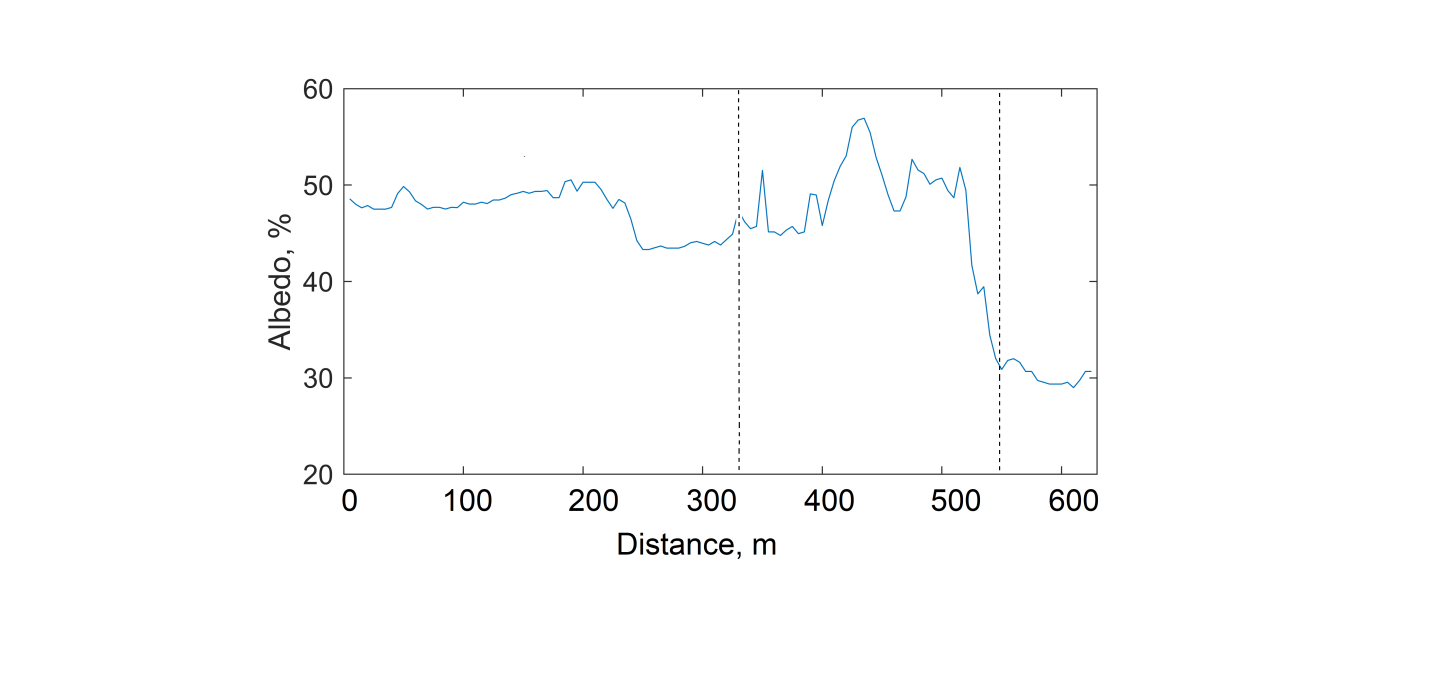
Figure 4 Albedo values along the UAV flight profile over the marginal zone.
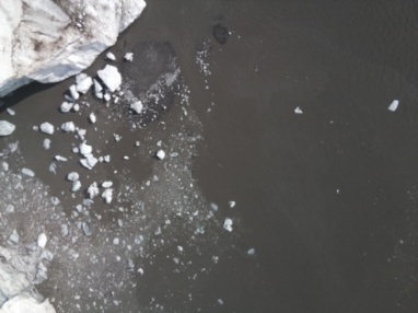
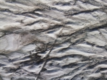
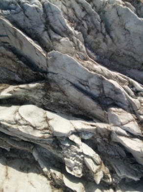
The actual zone of cracks is limited by dotted lines (see photo in Figure 3). As follows from the figure, the albedo of the sea surface (adjacent to the ice barrier of the fjord water) is approximately 30%, which significantly exceeds the average albedo of sea waters. This can be explained by the large amount of fine and grated ice on the surface of the fjord waters, which is formed as a result of the constant spalling (collapse) of fragments of the ice barrier (see photo in Figure 5a). The albedo values are characterized by significant variability directly in the edge zone of the glacier (zone of cracks). The average albedo values in the area immediately adjacent to the flat surface of the dome (see photo in Figure 5b) do not exceed 50%. Directly in the zone of cracks (see photo in Figure 5c), the albedo varies from 30 to 58%. This circumstance may be due to the increasing slope of the glacier surface directly in the edge zone, in comparison with the relatively horizontal sections adjacent to the dome. Taking into account the height of the sun, the angles of incidence of sunlight (direct solar radiation) can reach 90 degrees on such areas of the glacier surface. In such cases, the reflection is minimal and the albedo decreases. On the other hand, the incidence of sunlight on the vertical walls of deep cracks can lead to multiple re-reflection of the incident ray, including into the depth of the crack. This should lead to a decrease in the reflected radiation and be the reason for a decrease in the albedo values. Also, the marginal zone is characterized by the alternation of sunlit and shaded areas of the glacier surface. This can also explain the decrease in the surface albedo, all other things being equal.
| 
| 
|
| (a) | (b) | (c) |
| Figure 5 Typical surface types of the Esmark glacier: (а) – see water surface; (b) – flat area (dome); (c) – crack zone. | ||
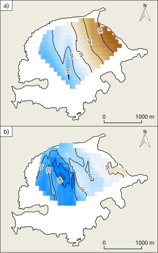
The use of the UAV made it possible to estimate the albedo of a significant part of the surface of the Aldegonda glacier, spending no more than one hour on flights along the profiles (see Figure 1). In the framework of standard ground-based observations, this requires at least a day, which is associated with limited routes for safe movement along the glacier [4]. The spatial distribution of albedo was obtained for various weather conditions and the state of the glacier surface. One UAV flight was carried out in the complete absence of snow on the surface (the snow melted), the second - after a short snowfall. In both cases, cloudy conditions did not allow using the capabilities of high spatial resolution satellites in the visible range (Landsat or Sentinel). The results are shown in figure 6.
| 
|
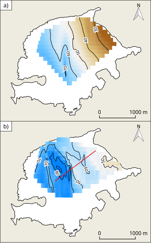
| Figure 6 Distribution of the albedo before (a) and after snowfall (b), red line – the route of ground observations.
| |
We compared ground observations made along the profile (“ground true” measurements) with the data obtained by UAV for the data verification. The results are shown in Figure 7.
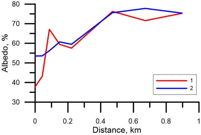
Figure 7 The albedo of the glacier surface obtained by ”ground true” measurements (1) and UAV (2).
As follows from the figure, the profile obtained by UAV is smoother than the profile drawn from the ground-based observations. This phenomenon can be explained by the difference of measuring technique. When measuring the reflected radiation from a certain altitude (UAV), the signal is formed by a larger area comparing with the one during the ground measurements. This leads to the well-known "smoothing" of the morphometric characteristics and color features of the glacier surface during this period of the year. The surface itself can have numerous features such as firn, fresh snow, melt water on the surface, pollution by rock particles, etc. Another possible reason is the use of interpolated values to build a profile by UAV. The main trend is an increase in albedo with height. It is clearly visible in both approaches, while the absolute values coincide, especially in the central part of the profile.
5. Conclusions
Field experiments carried out over the Svalbard glaciers have shown the high efficiency of using UAV for assessing the albedo of the underlying surface. For the first time, it was possible to estimate the albedo in the marginal zone of the cracks of the outlet type glacier (Esmark Glacier, Isfjord Bay). Such measurements cannot be performed by standard methods and means. The estimates obtained will make it possible to more correctly calculate the heat balance of the glacier surface in such a dynamic zone, which will undoubtedly contribute to an objective assessment of the mass balance of the glacier as a whole. Areal surveys of the Aldegonda Glacier (Greenfjord Bay) made it possible to obtain estimates of the albedo of its surface for various snow and surface conditions. The use of UAVs makes it possible to estimate short-term changes in the albedo of the underlying surface, which is impossible when using satellite images due to the discreteness of flights and cloud conditions.
|
|
|
© helpiks.su При использовании или копировании материалов прямая ссылка на сайт обязательна.
|