- Автоматизация
- Антропология
- Археология
- Архитектура
- Биология
- Ботаника
- Бухгалтерия
- Военная наука
- Генетика
- География
- Геология
- Демография
- Деревообработка
- Журналистика
- Зоология
- Изобретательство
- Информатика
- Искусство
- История
- Кинематография
- Компьютеризация
- Косметика
- Кулинария
- Культура
- Лексикология
- Лингвистика
- Литература
- Логика
- Маркетинг
- Математика
- Материаловедение
- Медицина
- Менеджмент
- Металлургия
- Метрология
- Механика
- Музыка
- Науковедение
- Образование
- Охрана Труда
- Педагогика
- Полиграфия
- Политология
- Право
- Предпринимательство
- Приборостроение
- Программирование
- Производство
- Промышленность
- Психология
- Радиосвязь
- Религия
- Риторика
- Социология
- Спорт
- Стандартизация
- Статистика
- Строительство
- Технологии
- Торговля
- Транспорт
- Фармакология
- Физика
- Физиология
- Философия
- Финансы
- Химия
- Хозяйство
- Черчение
- Экология
- Экономика
- Электроника
- Электротехника
- Энергетика
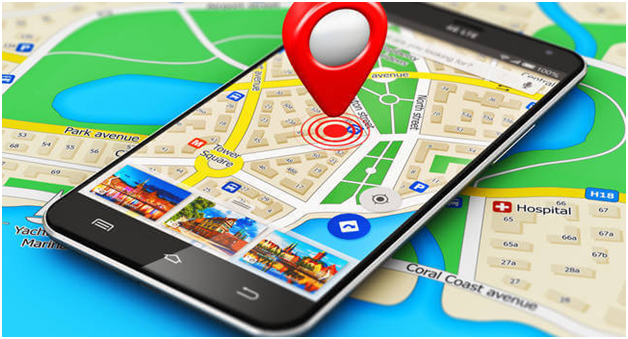
I use Google Maps
What is GSM?
GSM (Global System for Mobile communication) is a digital mobile telephony system that is widely used in Europe and other parts of the world. GSM uses a variation of time division multiple access (TDMA) and is the most widely used of the three digital wirelesstelephony technologies (TDMA, GSM, and CDMA). GSM digitizes and compresses data, then sends it down a channel with two other streams of user data, each in its own time slot. It operates at either the 900 MHz or 1800 MHz frequency band. Mobile services based on GSM technology were first launched in Finland in 1991. Today, more than 690 mobile networks provide GSM services across 213 countries and GSM represents 82.4% of all global mobile connections. According to GSM World, there are now more than 2 billion GSM mobile phoneusers worldwide. GSM World references China as "the largest single GSM market, with more than 370 million users, followed by Russia with 145 million, India with 83 million and the USA with 78 million users."
What is 3G?
3G, standing for third generation, is the third generation of wireless mobile telecommunications technology. It is the upgrade for 2G and 2.5G GPRS networks, for faster internet speed. This is based on a set of standards used for mobile devices and mobile telecommunications use services and networks that comply with the International Mobile Telecommunications-2000 (IMT-2000) specifications by the International Telecommunication Union. 3G finds application in wireless voice telephony, mobile Internet access, fixed wireless Internet access, video calls and mobile TV.
3G telecommunication networks support services that provide an information transfer rate of at least 2 Mbit/s. Later 3G releases, often denoted 3.5G and 3.75G, also provide mobile broadband access of several Mbit/s to smartphones and mobile modems in laptop computers. This ensures it can be applied to wireless voice telephony, mobile Internet access, fixed wireless Internet access, video calls and mobile TV technologies.
A new generation of cellular standards has appeared approximately every tenth year since 1G systems were introduced in 1981/1982. Each generation is characterized by new frequency bands, higher data rates and non–backward-compatible transmission technology. The first 3G networks were introduced in 1998 and fourth generation 4G networks in 2008.
What is 4G?
4G is the fourth generation of mobile phone technology that follows on from the existing 3G and 2G mobile technology.
2G technology launched in the 1990s and was capable of making digital phone calls and sending texts. Then 3G came along in 2003 and made it possible to browse web pages, make video calls and download music and video on the move.
4G technology builds upon what 3G currently offers, but does everything at a much faster speed.
What frequencies are used for 2G, 3G, 4G by Kazakhstan communication operators?
| 2G | 3G | 4G LTE | |
| Altel | 900MHz | 850 MHz,900 MHz(BS Tele2) | 1800 MHz - band3 |
| Beeline | 900 MHz | 2100MHz | Almaty and Shymkent - 800 MHz (Band 20) and 1800 MHz (band 3); Uralsk and Aksay - 1800 MHz (band 3);in the remaining cities the network works at the frequency of 800 MHz (band 20); in pilot zones of Almaty at a frequency of 2100 MHz (band 1) |
| Kcell | 900 MHz | 2100 MHz | Almaty and Shymkent - 800 MHz (Band 20) and 1800 MHz (band 3); in the remaining cities - at a frequency of 800 MHz (band 20);in pilot zones at a frequency of 2100 MHz (band 1) |
| Tele2 | 900 Of MHz | 900 MHz,850 | 1800 MHz - band3 (base stations Altel) |
| MHz(BS Altel) |
Features of your smartphone:
| Brand Name | Samsung Galaxy |
| Model | Samsung Galaxy J5 (2016) |
| Operation System | Android |
| SIM Card Quantity | |
| ROM | 16GB |
| CPU | Quad-core 1.2 GHz Cortex-A53 |
| RAM | 2GB |
| 2G: | 850, 900, 1800, 1900 МГц |
| 3G: | 850, 900, 1800, 1900 МГц |
| 4G: | 800, 850, 900, 1800, 2100, 2600 МГц |
| Display Size | 5.2 inches, 74.5 cm2 (~70.7% screen-to-body ratio) |
| Battery Capacity(mAh) | 3100mAh |
| Camera | Photo / Video. 13 megapixel |
| Display Resolution | 720 x 1280 pixels, 16:9 ratio (~282 ppi density) |
| Release Date | 2016 April |
TASK 3: What is GPS?
GPS - the satellite system of navigation providing measurement of distance, time and defining location in the world system of coordinates of WGS 84. Allows in any place of Earth (excepting subpolar areas), almost under any weather conditions and also in near-earth space to define location and speed of objects.The basic principle of use of system — positioning by measurement of timepoints of reception of a synchronized signal from navigation companions of the antenna consumer
How does the GPS navigator work?
The invention of satellite system of navigation on the significance is almost equal with the invention of the mobile phone, satellite television and telephony. Any person who at least appeared once in the unfamiliar place will appreciate this invention of the twentieth century. Today GPS – navigation acquires huge popularity among tourists, hunters and fishermen, motorists and just fans of the active recreation. rcsz-tcc.ru can recommend the GPS navigator to the one who needs to know where it is as it is better to reach a destination point with what speed it moves and when gets to the right place. The system is 24 satellites which rotate on six orbits, earth-based stations of tracking, a communication system and central control. An inclination of orbits of satellites to the equator of Earth - 55 degrees, and a corner between the plane of orbits - 60 degrees. Each of satellites weighs less than one ton, and length – about five meters. Power of radio transmitters - is no more than 50 W. Estimated operating time of the satellite – ten years. New satellites are launched into a terrestrial orbit as required. Besides, the GPS satellites can move on orbits, filling gaps in system in case one of them has ceased to work. An important element of satellites is the atomic clock (on four on everyone).
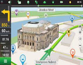
Briefly review popular GPS-navigators for smartphones
Navitel Navigator — the paid program for satellite navigation released by the Russian company JSC Centre Navigatsionnykh Tekhnology. The first sales of the Navitel Navigator program have begun in Russia at the end of 2006. The cartographical basis, according to the producer, is provided by Roskartografiya with the subsequent processing by the organization (regarding specification of location of objects, drawing additional layers, etc.) For the third quarter 2016 JSC TsNT has managed to issue detailed navigation charts of all Russia, including 13 324 cities and settlements with high specification. • Offline cards. For operation with the program and cards the Internet is not necessary: saving in roaming and independence of communication quality in regions. Access to cards at any time: cards boot in memory of the device or on a SD card. Navigation charts of 64 countries of the world are available to purchase.Subscription to cards: purchase of cards for a limited time frame (1 year), from 790 rubles is possible (except Russia maps, Belarus, Ukraine, Kazakhstan and also the packets including at least one of cards of these countries).
 Yandex. The navigator — a navigation mobile application from the Russian company Yandex. The application is free and available to smartphones and tablets on the iOS, Android and Windows Phone platforms.
Yandex. The navigator allows to lay routes taking into account traffic jams, at the same time there are voice hints (are by default available a male and female voice ). The application shows road events and schemes of houses and automatically switches from the three-dimensional mode in two-dimensional Speed, the expected arrival time and distance to the purpose is shown . There is a search of the necessary objects nearby (movie theaters, restaurants, gas stations, etc.), a view from the satellite; besides, routes are available across all Russia . The route is laid through intermediate points, there is a voice search . Application works in the online mode and permanently pumps up the absent or updated sections of cards in a cache . Offline mode is also available and joins automatically when the signal of a mobile network becomes feeble or absolutely disappears. For operation without connection to a network it is necessary to save region cards in memory of the device in advance.

2GIS" (it is said "двагис" ; before rebranding in 2011 — DoubleGIS) — the international cartographical company publishing the electronic eponymous reference books with maps of the cities since 1999. All versions of "2GIS", as well as updating to them, are free for users. The main source of revenues of the 2GIS company — sale of the spaces on the card and in the reference book (a banner, the place in the list, the additional text) .
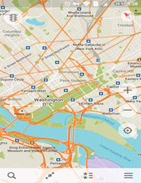
MAPS.ME (the former name — MapsWithMe, Russian cards with me) — the free application for mobile devices on the basis of the free map of OpenStreetMap. Since November, 2014 Maps.me possesses Mail.ru Group and develops within her international My.com project. The Maps.me applications are available on the platforms iOS, Android (including assemblies to Amazon Kindle Fire tablets) and Blackberry. Before work the application loads maps of the city or the countries with all objects into memory of the device and remains completely functional without connection to the Internet.
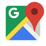 Google Maps is a web mapping service developed by Google. It offers satellite imagery, street maps, 360° panoramic views of streets (Street View), real-time traffic conditions (Google Traffic), and route planning for traveling by foot, car, bicycle (in beta), or public transportation.
I use Google Maps
|
|
|
© helpiks.su При использовании или копировании материалов прямая ссылка на сайт обязательна.
|